
In this post we continue to look at the CSO’s six way urban rural classification, this time examining it at county level. The classification was discussed in detail in the previous post when the categories and the differences between Western Region (counties Clare, Donegal, Galway, Leitrim, Mayo, Roscommon and Sligo) and the Rest of the State (the 19 counties not included in the Western Region) and between the categories were considered. We now have the opportunity to look at the classifications at county level in more detail and explore the differences among the Western Region counties.
As has been noted previously, the Western Region is a very rural region. Taken as a whole, only 36.9% of the population live in urban areas (that is settlements of more than 1,500 people, in an international context this is quite small to be classified as urban) while 63.1% of the population live outside of those settlements and are deemed rural. While there is much debate about where people should live and whether this is a sustainable settlement pattern, this is a historic legacy not a new development. This is shown by the similarity in the level of rurality in Northern Ireland[1], 36% of the population living in rural areas compared to 42.5% in the Republic of Ireland[2] (using the same definition as Northern Ireland, i.e. outside settlements of 5,000). These compare to the much lower 17% of the population in both England[3] and Scotland[4] (though they use different definitions of rurality (outside settlements of 3,000 in Scotland, outside settlements of 10,000 in England). Even though these are not directly comparable with the figures given for Ireland above, similar definitions would not give rise to similarly high levels of rurality.
The Urban /Rural typology in Western Region counties
In this, the second post on the CSO’s six way urban/rural classification, I take a more detailed look at the classification of the population by Western Region county. The six way urban rural classification is based on where the population works rather than other more commonly used characteristics of urban and rural areas and so the findings may vary from other approaches
The six way classification is defined as follows:
- Urban
- Cities
- Satellite Urban Towns
- Independent Urban Towns
- Rural (areas outside urban i.e. with a population less than 1,500)
- Rural Areas with High Urban Influence
- Rural Areas with Moderate Urban influence
- Highly remote/Rural Areas
For more details of the approach used see Urban and Rural Classifications Table in the Background Notes. The spatial distribution of the six categories is shown on the map (Figure 1) below.
Figure 1: Map Showing the Six Way Urban /Rural Classification
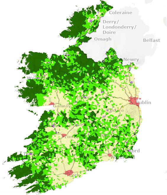
Source: CSO 2026 Urban and Rural Life in Ireland. To view an interactive map which shows the spread of the six area classifications across the country, click here
Urban areas in Western Region counties
Some 37% of the Western Region population lives in an urban area, compared to 69% of the population of the Rest of State (the 19 counties not part of the Western Region). In this classification, urban areas are divided into 3 categories. ‘Cities’ have a population greater than 50,000, ‘Satellite urban towns’ have a population between 1,500 and 49,999, where the workplace of 20% or more is in ‘Cities’, while ‘Independent Urban towns have a population between 1,500 and 49,999, where the workplace of less than 20% is in ‘Cities’ (see the previous post from more discussion), or for a full definition See Urban and Rural Classifications Table in the Background Notes.
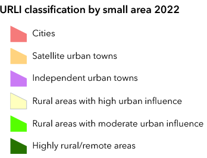
Figure 2 below shows the urban centres in the Western Region. The only city located within the Region is Galway, and there are six towns with a population of more than 10,000 (not including Athlone, as most of it is located outside the Western Region). The majority of the towns are smaller than 10,000 population.
Figure 2: Map of urban centres in the Western Region
Source: Western Development Commission
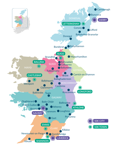
Cities
Looking at cities specifically (settlements with a population greater than 50,000), these accounted for just over 10% of the Western Region population and just over 38% of the population in the Rest of the State (Figure 3).
Figure 3: Percentage of the population in ‘Cities’ for Western Region counties, the Western Region and Rest of State
Source: CSO 2026, Urban and Rural Life in Ireland Table Table 4
Only two Western Region counties have a ‘city’ population, with Galway, unsurprisingly being the most significant, accounting for just over 30% of the population for Galway (city and county). More surprisingly just over 3% of the Clare population is designated as city dwelling. This population, living in the Corbally area, are considered to be part of Limerick city. None of the other Western Region counties have a city population.
‘Satellite Urban towns’ (where more than 20% of the working population work in cities) show a similar patten (Figure 4). In Clare 3.5% of the population are classified thus (the populations of Sixmilebridge and Killaloe, where many work in Limerick city, account for this). In Galway 12.5% of the population lives in a ‘Satellite urban town’ (Athenry, Bearna, Loughrea, Maigh Cuillinn (Moycullen), Oranmore, Oughterard and Tuam are in this category). Again, relating to the employment patterns influenced by distance from a city, no other Western Region county has any town population in this category.
Figure 4: Percentage of the population in ‘Satellite urban towns’ for Western Region counties, the Western Region and Rest of State
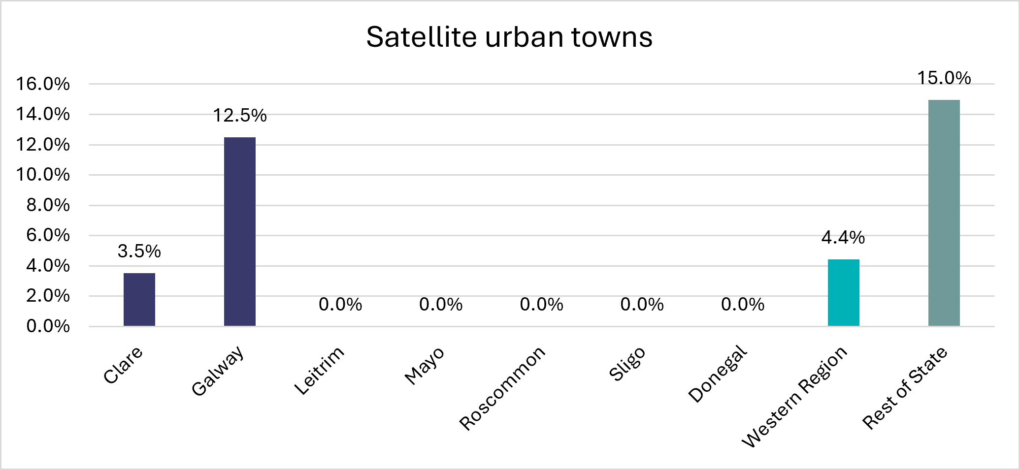
Source: CSO 2026, Urban and Rural Life in Ireland Table 4
Looking at the pattern overall, some 4.4%of the Western Region population live in ‘Satellite urban towns’ while 15% of the population in the Rest of State does.
The most important urban category for the Western Region is the ‘Independent urban town’ which is defined as a Town or Urban Area with a population between 1,500 and 49,999, where less than 20 percent of the usually resident employed population’s workplace address is in ‘Cities’. These towns account for 22.5% of the Western Region population, compared to 16% of that in the Rest of State (Figure 5). In the Western Region however, most of the towns in this category are quite small. Only six towns (excluding Athlone, whose population is largely outside the Region) in the Western Region have a population of over 10,000, while eight are between 5,000 and 10,000 and thirty are smaller than 5,000 (but larger than 1,500).
In Clare such towns (Ennis, Kilrush, Newmarket on Fergus, and Shannon) account for a third of the population (33.5%) and is the most significant of the six categories for this county. Likewise, it is the most important category for Sligo, accounting for 43% of the population, they are resident in Sligo town, Ballymote, Ballysadare, Collooney, Strandhill and Tubbercurry.
In Donegal, Mayo and Roscommon it is also a significant category accounting for 29% in each of these counties. In Donegal, this category includes residents in Letterkenny, Ballybofey-Stranorlar, Ballyshannon, Buncrana, Bundoran, Carndonagh, Convoy, Donegal town and Lifford. In Mayo the larger towns of Castlebar and Ballina, account for a significant portion of this, but people living in Ballinrobe, Ballyhaunis, Claremorris and Westport also fall into this category. In Roscommon, largest is Roscommon town itself, but the portion of Athlone in county Roscommon is also substantial while Ballaghaderreen, Boyle, Castlerea are also in this category.
Figure 5: Percentage of the population in ‘Independent urban towns’ for Western Region counties, the Western Region and Rest of State
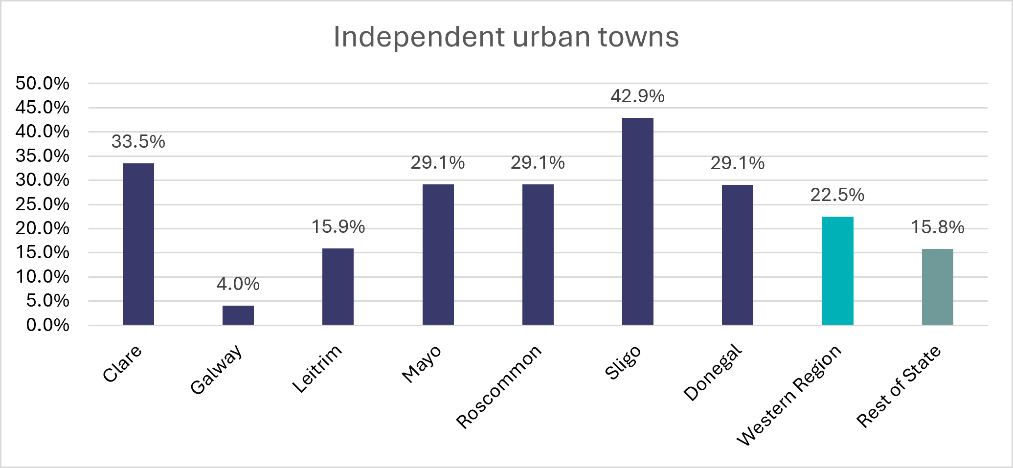
Source: CSO 2026, Urban and Rural Life in Ireland Table 4
Leitrim only has two towns in this category (Carrick on Shannon and Manorhamilton) and they account for almost 16% of the county population. Finally, Galway, has only 4% of the population in this category, as noted above, those living in the city or its satellites are more significant. Only Ballinasloe and Gort fall into the ‘Independent urban towns’ category.
Rural areas in Western Region counties
Some 63% of the Western Region population lives in areas classified as rural (that is outside urban settlements with a population of greater than 1,500), compared to 31% of the population of the Rest of State. In this classification rural areas are also divided into 3 categories, based on their dependence on urban areas as measured by the employment location of those who work in the three standard categories of urban area. The total working in each urban area were weighted through the use of multipliers which allowed for the increasing urbanisation for different sized urban areas. For a full definition see Urban and Rural Classifications Table in the Background Notes
The three ‘rural’ categories are:
- Rural areas with High Urban Influence
- Rural areas with Moderate Urban influence
- Highly remote/Rural Areas
This rural categorisation is perhaps most different from previous classifications, given that it is based on employment location rather than an intrinsic characteristic of the area itself (see the previous post for more discussion).
Looking first at ‘Rural areas with high urban influence’ (Figure 6), these account for 18.3% of the population of the Western Region, and 15.4% of the population of the Rest of State. It is the largest of the rural categories in the ‘Rest of State’ though, as noted above, a much smaller proportion of the Rest of State population lives in rural areas than does the Western Region population.
It is the most significant rural category in Galway, accounting for almost a third of the population (31.9%) while it is also very significant in Clare, accounting for more than a quarter of the town population (26%).
Figure 6: Percentage of the population in ‘Rural areas with high urban influence’ for Western Region counties, the Western Region and Rest of State
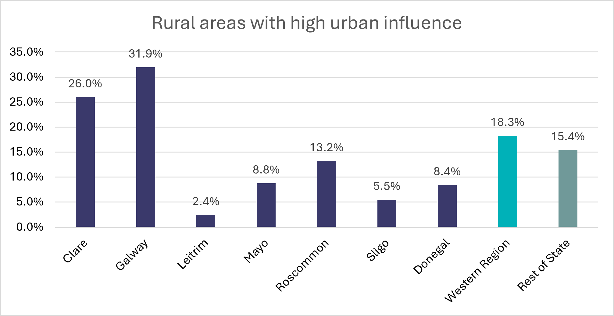
Source: CSO 2026, Urban and Rural Life in Ireland Table 4
The only other county where it accounts for more than 10% of the population is, somewhat unexpectedly, Roscommon where it accounts of 13.2% of the county population most of which is based in the southern part of the county, under the influence of Galway and perhaps Dublin (see pale yellow areas on the map above). This category is less significant in Mayo (8.8%) and Donegal (8.4%), followed by Sligo (5.5%) where it reflects the population based in proximity to the key towns while unsurprisingly Leitrim has the smallest proportion of its population in this category (2.4%).
‘Rural areas with moderate urban influence’ (Figure 7) is the most important category for Roscommon accounting for 31% of its population, but it is also an important category for Leitrim (28.8%) and Mayo (26.3%), it is relatively high in these counties as they have a large proportion of their population living in rural areas.
Figure 7: Percentage of the population in ‘Rural areas with moderate urban influence’ for Western Region counties, the Western Region and Rest of State
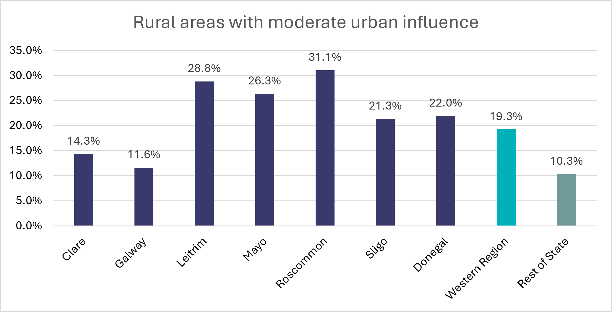
Source: CSO 2026, Urban and Rural Life in Ireland Table 4
Just over a fifth of the population in both Donegal (22%) and Sligo (21.3% ) live in rural areas of this category, which is less important in Clare (14.3%) and Galway (11.6%) which have larger urban populations. In the Western Region as a whole this category accounts for almost a fifth of the population (19.3%) compared to just over 10% in the Rest of State.
The final rural category to be considered is ‘Highly remote/rural areas’ which accounts for a quarter of the of the Western Region population (25.5%) but only 5.1% of that in the Rest of State (Figure 8).
It is the most important category in Leitrim, accounting for more than half of the population, (52.2%) followed by Donegal where it accounts for 40.5% of the population and Mayo where more than a third (35.7%) live in highly remote rural areas. It is also an important category in Sligo (30.3%) especially given the relative size of the urban population in that county, and accounts for over a quarter of the population of Roscommon (26.6%)
Figure 8: Percentage of the population in ‘Highly rural/remote areas’ for Western Region counties, the Western Region and Rest of State
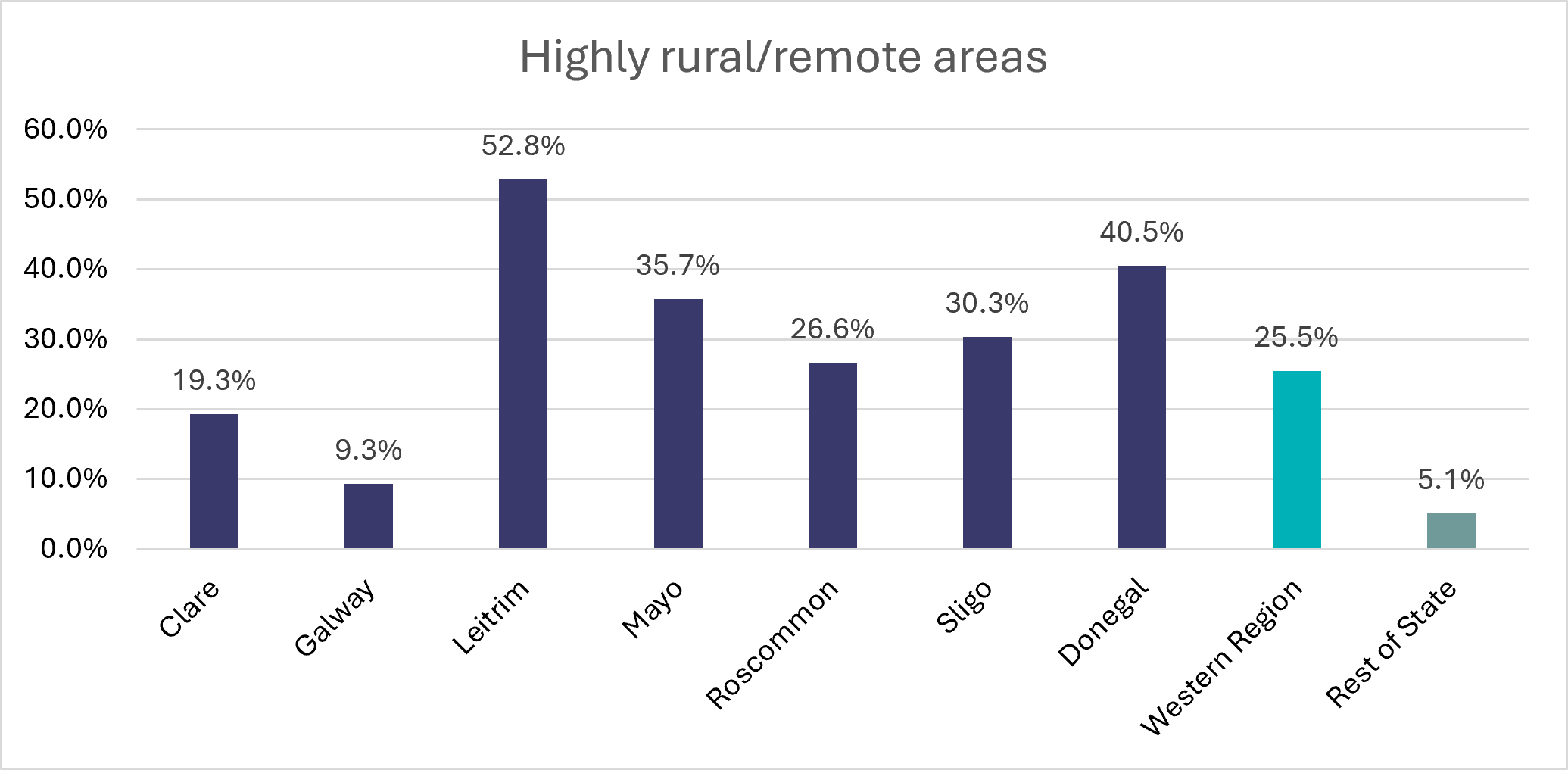
Source: CSO 2026, Urban and Rural Life in Ireland Table 4
It is less important in Clare (19.3%) and Galway where less than 10% of the population lives in these areas (even though there is a large part of the western part of that county which certainly feels rural and remote), reflecting the fact that this categorisation is based on the workplace of those in employment .
Conclusion
It is useful to have a six way breakdown of the Western Region population into urban and rural categories. As discussed previously, the use of workplace of those in employment for categorisation, gives rise to some unexpected patterns. The previous post noted some other methods of urban and rural classification. In future, if I have the opportunity, I would like to examine how the results of the different classification methods might vary.
Helen McHenry
[1] Northern Ireland 36% https://www.daera-ni.gov.uk/sites/default/files/2026-05/26.27.022 Key Rural Issues 2025.pdf
[2] Republic of Ireland 42.5% (own calculations from Table F1010)
[3] England 17% (though the definition of rural areas is outside 10k towns) https://commonslibrary.parliament.uk/research-briefings/cdp-2024-0119/
[4] Scotland areas with a population of less than 3,000 17% https://www.gov.scot/publications/rural-scotland-data-dashboard-overview/pages/2/