
The CSO recently published ‘Urban and Rural Life in Ireland’. This release uses a six-way urban/rural classification to examine social and economic characteristics of life in Ireland across urban and rural areas. The release provides interesting data on, for example, income, employment, health and families, but the focus of this post is on the categorisation of the population, and areas, into the different urban and rural categories.
Defining rurality is never ending quest (indeed I considered the issue previously in 2017 ‘What is Rural?’), with various definitions used based on things like population, density, accessibility (journey time, for example) and by exclusion (what is not urban). There are therefore different definitions used by the Irish government (a flexible approach), although the OECD has suggested that policy monitoring is hindered by the lack of a consistently applied definition of “rural” across government departments. Internationally a variety of definitions are used by the EU (based on map grid areas not classified as urban); by the OECD (a combination of population density, regional characteristics and accessibility); by the Scottish government (population and accessibility based, outside an urban population (3,000+); and in Northern Ireland (population and accessibility based, but with a definition of urban population as 5,000+). The main classification for urban and rural from the CSO is simple, any settlement (or Built Up Area (BUA)) with a population of more than 1,500 is urban, otherwise it is rural.
However, the CSO also developed a six way categorisation for ‘Urban and Rural Life in Ireland’ breaking Urban into three Types and Rural into 3 types. Unusually, however, the main metric used by the CSO for classifying rural areas was location of employment. I have not seen discussion of the reasons for this choice, it may relate to planning criteria, or the concept of ‘urban generated housing’ or issues of data availability.
While the definition of rurality is both interesting and important, the focus of this post is on how the six-way urban/rural classification, developed by the CSO following Census 2016 (and updated with Census 2022 data) applies in the Western Region (the seven counties under the remit of the WDC).
The six way breakdown is as follows:
Urban areas are built-up areas with populations greater than 1,500 which are further classified (based on proportion of workplaces in Cities) into:
- Cities (population more than 50,000)
- Satellite urban towns, and
- Independent urban towns .
Rural areas are places outside these urban areas (i.e. outside settlements of 1,500+) and are classified as:
- Rural areas with high urban influence
- Rural areas with moderate urban influence
- Highly rural/remote areas
Note that the classification of rural areas, and urban settlements other than cities, is based on the employment locations of the residents rather than geographical characteristics. See Urban and Rural Classifications Table in the Background Notes.
The Western Region is one of the most rural parts of Ireland, but it is interesting to consider the nature of rurality (and indeed urban centres) across the Region. In Figure 1, the six way classification is shown for Ireland, and it is evident that Western Region counties have very significant population in the two most rural categories (light and dark green). The influence of Galway, Limerick, and perhaps Dublin in parts of the Region, is shown by the pale yellow colour.
Figure 1: Map Showing the Six Way Urban /Rural Classification
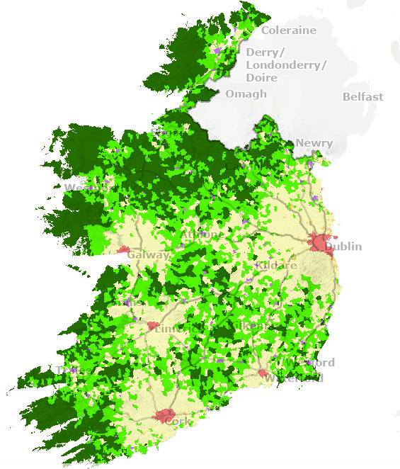
Source: CSO 2026 Urban and Rural Life in Ireland . To view an interactive map which shows the spread of the six area classifications across the country, click here
The map gives a broad overview but it is useful to consider the characteristics of the Western Region as a whole and the population living in each of these types of areas. Understanding the nature of rurality in our Region, and the role and influence of different types of urban areas, can help us to better understand the impacts of different policies in our Region.
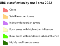
Urban and rural classification in the Western Region.
As noted above, the six way urban rural classification involves the categorisation of urban and rural into three subcategories, largely based on employment location. In the 2022 Census 36.9 % of the Western Region population was classified as urban and 63.1% as rural.
The Urban Western Region
Using the six way classification in the Western Region (Figure 2) the urban category (comprising 36.9% of the Western Region population) is made up three different types of urban areas. Of those, 10 % of the population is living in Cities. That population classified as living in Cities (Built Up Areas with populations greater than 50,000, red on the map) is mostly made up of those living in Galway, with a small percentage of the population living in the Corbally area of Co. Clare which is classified as part of the Limerick ‘City’ category.
‘Satellite urban towns’ (4%) is the smallest Western Region category (defined as Built Up Areas with populations between 1,500 and 49,999, where 20% or more of the usually resident employed population’s workplace address is in ‘Cities’ ). Only Clare and Galway in the Western Region have towns in this category (shown as orange on the map). Finally, the largest urban category in the Region is ‘Independent urban towns’ (22%) and includes most towns with a population of more than 1,500 in the Western Region. Independent towns (purple on the map) are defined as Built Up Areas with populations between 1,500 and 49,999, where less than 20% of the usually resident employed population’s workplace address is in ‘Cities’.
Figure 2: Population in Urban and Rural Categories in the Western Region
Source: CSO 2026, Urban and Rural Life in Ireland Table 4
The Rural Western Region
As noted above, in 2022, 63% of the Western Region population lived in rural areas, but the means of defining these categories is more complex than that for urban areas, relating to location of employment and town type with a series of weightings and multipliers used for the categorisation (see the CSO explanation here or the footnote below[1]).
‘Rural areas with high urban influence’ (18% of the Western Region population) are mostly around Galway city, Limerick and in closer proximity to the larger ‘Independent urban towns’ (see the pale yellow areas on the map above). ’Rural areas with a moderate urban influence’ (light green) is a slightly larger category (19% of the Western Region population) and is more widely spread throughout the Region, and indicates the close connection between the smaller rural towns and their hinterlands, for the purposes of employment. As has been noted previously (here and here) urban centres (towns larger than 1,500) in the Western Region are more likely to be employment centres than their counterparts in the east (and to a lesser extent, the south) where towns of that size are more likely to have a population commuting elsewhere to work. The largest of the rural categories in the Western Region accounts for more than a quarter of the population with 26% living in ‘Highly rural/remote areas’.
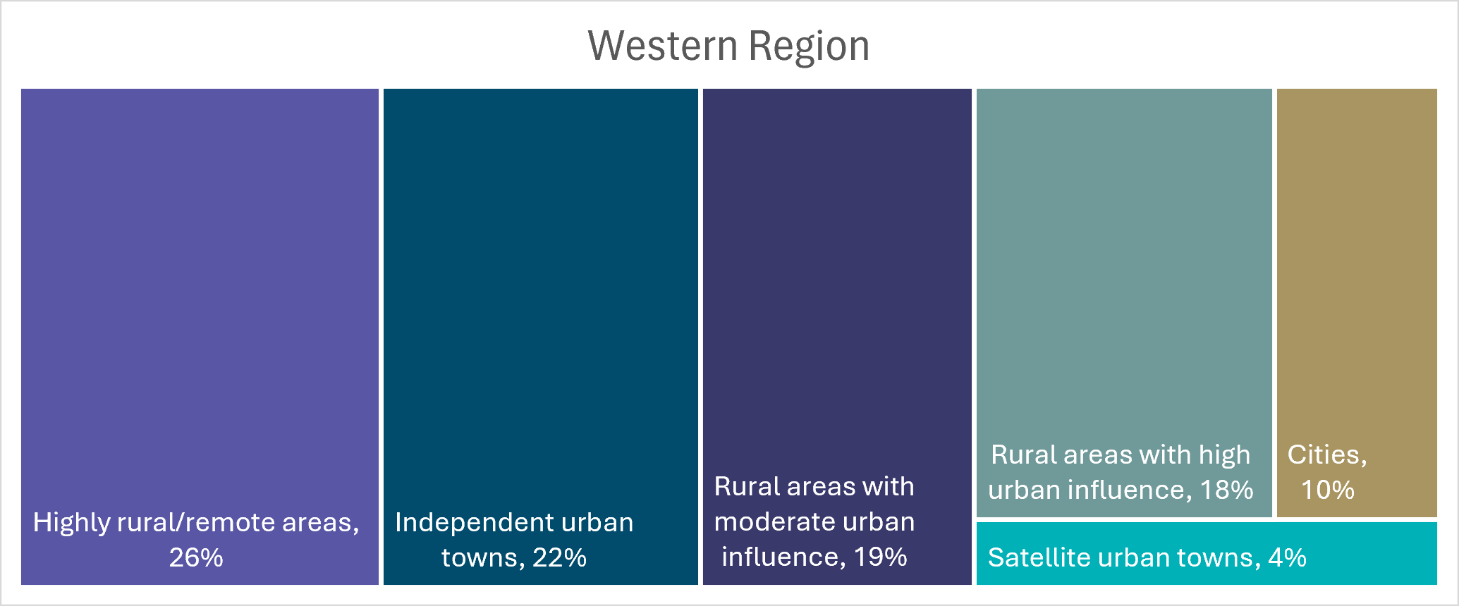
The rural nature of the Western Region has been well discussed but it is useful to compare (Figure 3) the Region’s characteristics with the Rest of State (the population in the 19 counties not in the Western Region). The most significant difference between the Western Region and Rest of State relates, not surprisingly, to the population living in cities. In the Western Region it is 10% compared to 38% in the Rest of State. Similarly, the while only 4% of the Western Region population lives in Satellite urban towns, 15% of the Rest of State population does. In contrast, the category ‘Independent urban towns’ which covers most urban areas in the Western Region accounts for a higher proportion of the population in the Western Region (22%) than in the Rest of State (16%) reflecting the limited influence of cities throughout most of the Western Region
Figure 3: Western Region and Rest of State Population by Urban and Rural Location (2022)
Source: CSO 2026, Urban and Rural Life in Ireland Table 4
In terms of the rural categories, the very rural nature of the Western Region means that, in all three of the categories, the Western Region has a larger proportion of the population living in them than the Rest of State. The strong urban influence elsewhere means that ‘Rural areas of high urban influence’ have most similar population levels (18% of the Western Region population, and 15% of that of the Rest of State). The difference is larger for ‘Rural areas with moderate urban influence’, with 19% of those living in the Western Region, compared to 10% of those in the Rest of State. Finally, the ‘Highly rural/remote area’ category shows the greatest difference, with more than a quarter of the Western Region population living in areas in this category, compared to 5% in the Rest of State.
While this post has examined the types of urban areas and rurality in the Western Region as a whole, there is of course spatial nuance and wide variation among the seven Western Region counties as can be seen in Figure 4. As noted above, only Clare and Galway have any population living in ‘Cities’, or in ‘Satellite urban towns’. This is somewhat unexpected giving the strong commuting populations in the towns surrounding Sligo but relates to the definition used, effectively the ‘Satellite urban towns’ can only be satellites of cities, not of other towns. ‘Independent urban towns’ are stronger elsewhere, but this category, the dominant urban one in the Western Region, puts key large (in the regional context) service centres like Ennis, Sligo and Letterkenny in the same category as small commuting towns like Ballysadare and Newmarket on Fergus, along with other rural towns which are established local centres serving a wide hinterland (Carrick on Shannon, Roscommon ) or small local centres (e.g. Manorhamilton , Carndonagh).
Figure 4: Population in Urban and Rural Categories in Western Region Counties, 2022
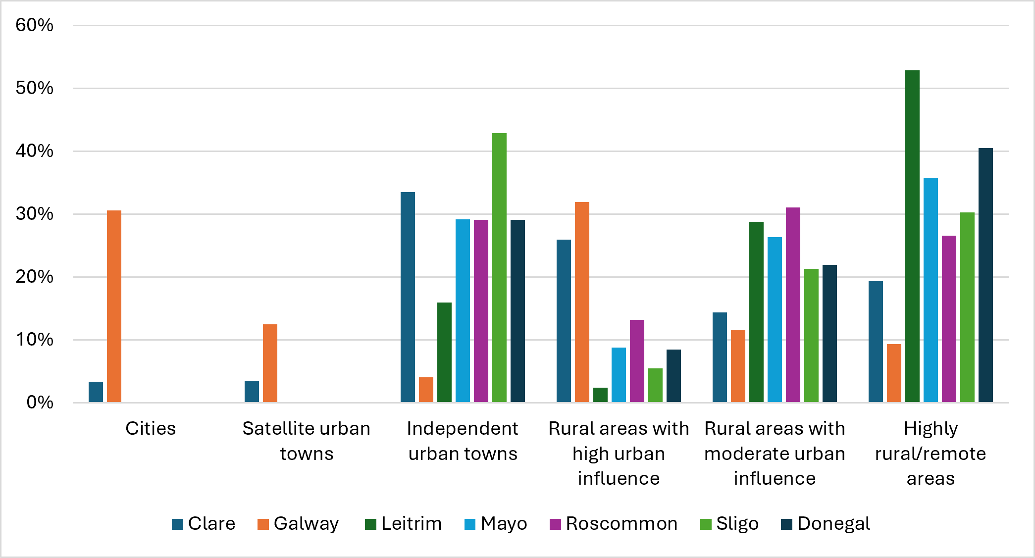
Source: CSO 2026, Urban and Rural Life in Ireland Table 4
In terms of rurality, the ‘Rural areas with high urban influence’ category is strongest where there is a city (Galway, Clare) while ‘Highly Rural/ Remote areas’ is strongest in the north west (Leitrim and Donegal). Rather than examine the different urban /rural categories for each county here, they will be discussed in the next post .
Conclusions
Agreeing definitions of rural areas seems equivalent to counting angels dancing on the head of a pin, and it can distract from the focus of policy and lead to unproductive debate. Yet definitions are important, and should match the policy context or the focus of analysis. We need to think about why we need to know about the urban and rural populations and how they are defined, and then use the most relevant definitions. For example, does our need relate to policy on employment, service levels, education, transport or housing and planning? However, as noted above, the OECD has suggested that the lack of a single definition of rural makes it more difficult to monitor rural policy and rural change.
Employment location is one way to define categories of rural areas, it does not necessary align with the needs, requirements and characteristics of the rural areas which are not employment related. It is suggested that the six way classification will be relevant to policy issues such as distance to services and service provision, yet these do not influence the definition and there is no information on how closely they are aligned. For example, would distance to service or population density metric give rise to the same or very similar categories? Of course, it is likely the different definitions of rural areas will give rise to similar categories, but it would be interesting to better understand why the employment criteria were used in the definition of urban type and rurality. The six way classification is of course useful, and indeed the ESRI report on monitoring rural development policy recommends:
Ensuring all government statistics are available at a spatially disaggregated level is key, and enhanced use of the CSO’s six-way urban–rural classification is also a key recommendation of this study. (pg. x)
Yet, without understanding how employment location relates to rural service needs (for example, is employment location the best variable for some Small Areas (almost 300 of which have fewer than a third of the population over 15 classified as ‘At Work’[2]) it is hard to be certain this is the best means of deriving a nuanced classification. Likewise, given that it appears to be a unique method of classifying rural area, it could make international, or even historical comparison more difficult.
This post has delved further into how our Region may be defined and gives us insights into how the Western Region may be categorised according to this definition. I consider the patterns at county level in more detail in the next post.
Helen McHenry
[1] The CSO provides the following detail in the Urban and Rural Classifications Table in the Background Notes. Rural areas (themselves defined as having an area type with a population less than 1,500 persons, as per Census 2022) are allocated to one of three sub-categories, based on their dependence on urban areas. Again, employment location is the defining variable. The allocation is based on resident employed adults of a rural Small Area who work in the three standard categories of urban area (for simplicity the methodology uses main, secondary and minor urban area). The total working in each urban area were weighted through the use of multipliers. The multipliers allowed for the increasing urbanisation for different sized urban areas. For example, the number of rural people working in a main urban area had double the impact of the same number working in a minor urban area. The weighting acknowledges the impact that a large urban centre has on its surrounding area. The adopted weights for: Main Urban areas is 2. Satellite urban communities is 1.5. Independent urban communities is 1. The weighted number of workers are divided into tercile to assign one of the three rural breakdowns.
[2] Own calculations from https://data.cso.ie/table/SAP2022T8T1SA There are 18,920 SAs so this might not be considered important.